Green Commuting Options in Houston: A Complete Guide
Houston has a reputation as one of America’s most car-dependent cities , and in many ways, that reputation is earned. But a quieter transformation has been underway for years. The city that built itself around the freeway is now investing seriously in light rail, protected bike lanes, electric bus fleets, and one of the most extensive Park & Ride systems in the country. For Houston commuters who are ready to reduce their carbon footprint, their fuel bill, or both, the options are better than most people realize.
The stakes are real. According to the City of Houston’s Climate Action Plan, transportation accounts for 47% of Houston’s total greenhouse gas emissions , making it the single largest source of the city’s carbon output. The plan sets a goal of reducing community-wide emissions 40% below 2014 levels by 2030 and reaching carbon neutrality by 2050. Individual commuting choices, at scale, are one of the most powerful levers to get there.
This complete guide covers every practical green commuting option available to Houstonians right now , from METRORail and Park & Ride buses, to bike share and e-bikes, to carpooling and vanpooling programs, to the city’s growing EV charging network. We’ll show you exactly what each option costs, where it works best, and how to get started. For a deeper look at the financial side, see our guide on ridesharing vs. car ownership costs in Houston.
🌿 Why Green Commuting Matters in Houston , By the Numbers 47% , Share of Houston’s greenhouse gas emissions coming from transportation (Houston Climate Action Plan, 2020) 40% , Target reduction in community-wide GHG emissions below 2014 levels by 2030 2050 , City of Houston’s goal year for carbon neutrality ~$10,000 , Annual carbon emissions saved per vehicle removed from daily road use (EPA estimate) 206,800 , Average weekday METRO boardings in Q4 2025 (bus + rail combined) 400+ miles , Bike lanes and trails built in Houston since adopting the Houston Bike Plan in 2017 2,726 , Total public EV charging stations in the Greater Houston–The Woodlands–Sugar Land metro area (PlugShare, 2025) |
Option 1: METRORail , Houston’s Light Rail Network

Houston’s METRORail is a 22.7-mile light rail system operated by the Metropolitan Transit Authority of Harris County (METRO).
It recorded 12.65 million boardings in 2025, averaging about 35,100 riders per weekday , and holds the title of the second most-traveled light rail system in the Southern United States and the highest ridership
per mile for light rail in the South. For green commuters living or working along its corridors, it is the fastest, most emissions-efficient option in the city.
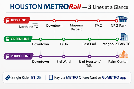
The Three METRORail Lines
Line | Key Stops | Best For |
Red Line | Downtown, Museum District, Rice U, Texas Medical Center, NRG Park | Medical Center workers, downtown office commuters, museum visitors |
Green Line | EaDo, East End, Magnolia Park | East Houston residents commuting downtown |
Purple Line | U of Houston, Texas Southern U, Palm Center | Students, Third Ward residents, southeast Houston commuters |
Fares and How to Pay
- Single ride: $1.25 per boarding , one of the most affordable light rail fares in any major U.S. city
- Day Pass: Available for unlimited rides in a single day
- METRO Q Fare Card: Reloadable card available at ticket vending machines at every station and at select retailers. Faster boarding than cash or single-ride tickets
- GoMETRO app: METRO’s all-in-one app for trip planning, real-time tracking, and mobile fare payment , available for iOS and Android
💡 METRORail Pro Tips for Green Commuters Park & Rail combo: Drive to a Park & Ride lot, then connect to METRORail at key transfer stations. This eliminates downtown parking costs ($125–$280/month) while keeping your schedule flexible. Texas Medical Center: The Red Line drops you right at the TMC , the largest medical complex in the world, with over 60,000 employees. Skipping the parking garage battle alone is worth it. NRG Park events: The Red Line runs to NRG Stadium for Texans games, concerts, and the Houston Livestock Show & Rodeo , eliminating event parking entirely. Free WiFi: METRO has rolled out WiFi access across its rail and bus fleet, making your commute productive time. |
Option 2: METRO Bus & Park and Ride
METRO’s bus network is the most used in Texas and the largest in the Southwest region, with 1,230 buses serving hundreds of routes across Harris County and surrounding areas.
For green commuters who don’t live near a METRORail line , which describes the majority of Houstonians , the bus network and Park & Ride system are the most practical low-emissions commuting tools available.
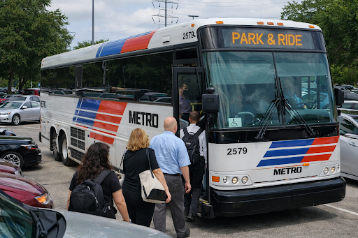
Park & Ride: The Green Commuter’s Best-Kept Secret
METRO operates 29 Park & Ride lots across the Greater Houston region with more than 33,000 parking spaces. The concept is simple: drive to a suburban Park & Ride lot (free parking), board an express bus with direct, often non-stop service to Downtown Houston, the Texas Medical Center, Greenway Plaza, or the Energy Corridor, and arrive faster than you would have on the freeway , especially during rush hour, when buses use dedicated HOV lanes.
- Cost: $2.00–$4.50 per ride depending on distance zone, versus $10–$20/day for downtown parking plus fuel costs
- HOV lanes: METRO Park & Ride buses use the HOV/HOT lanes on I-10, I-45, US-290, and other corridors , often cutting trip times by 20–40 minutes vs. driving alone
- Emergency Ride Home program: Registered Park & Ride riders who have a mid-day emergency or unplanned overtime get a free ride home , eliminating the biggest anxiety about leaving your car at home
- The Woodlands Express: A commuter bus service separate from METRO that operates from three Park ‘n’ Ride lots in The Woodlands, providing frequent weekday service to downtown Houston, Greenway Plaza, the Medical Center, and Greenspoint
METRO’s Electric and Hybrid Fleet
METRO currently operates 443 diesel-hybrid buses, reducing nitrogen oxide emissions by more than 50% compared to conventional diesel buses. The agency has a goal to purchase only zero-emission buses after 2030 and transition to a fully zero-emissions fleet. Two routes have already transitioned: Route 402 Bellaire Quickline is now all-electric, and Route 28 OST–Wayside has five electric buses in operation. METRO is investing $10 million in microtransit options for FY2025, including free electric vehicle service covering downtown, the Heights, Near Northside, Second Ward, and Third Ward through the METRONow program.
METRORapid: Bus Rapid Transit
The METRORapid Silver Line is METRO’s only current Bus Rapid Transit (BRT) line, connecting the Uptown/Galleria area with the Northwest Transit Center along dedicated bus lanes for nearly its entire 4.7-mile length. Opened in August 2020, it offers faster, more reliable service than standard local bus routes and is part of METRO’s broader plan to develop a 75-mile BRT network across Houston.
📋 Park & Ride Quick Reference , Key Houston Corridors I-45 North (toward downtown): Routes 202, 204 , Serve Greenspoint, Kingwood, Humble I-45 South (toward downtown): Routes 246, 247 , Serve Clear Lake, Pearland corridor US-290 / Northwest: Routes serving Northwest Transit Center with connections to Galleria area I-10 West / Katy: Routes serving Addicks and Mission Bend Park & Rides, connecting to Energy Corridor Grand Parkway / US-99: Route 222 with frequent service including express connections The Woodlands: Woodlands Express , 3 Park ‘n’ Ride lots, service to downtown and Medical Center Find your route: ridemetro.org or the GoMETRO app |
Option 3: Cycling and Houston BCycle
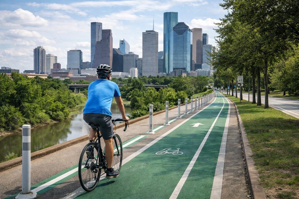
Houston has undergone a genuine ;cycling infrastructure transformation since adopting the Houston Bike Plan in 2017.
That plan set an ambitious goal: build 1,800 miles of high-comfort bikeways and achieve gold-level bicycle-friendly city status by 2027.
As of 2025, Houston has built over 400 miles of bike lanes and trails, with Harris County and municipal utility districts contributing an additional 160+ miles within city limits. The city’s bikeway network now spans more than 500 square miles.
Houston BCycle , The City’s Bike Share System
Houston BCycle is the city’s non-profit bike share organization, launched in 2012 with just three downtown stations and 18 bikes. It has since grown to more than 150 stations and 1,100 bikes citywide, including a growing fleet of electric-assist e-bikes. In its first ten years, Houstonians took 1.6 million BCycle trips , riding 9.6 million miles and generating an estimated 9,068 pounds of carbon offset. Visit Houston BCycle’s website for current station locations and pricing.
- Classic bike rental: Available by the hour, day, or via monthly/annual membership. Most affordable for frequent short trips
- E-bike rental: Electric-assist bikes available at select stations for an additional fee , ideal for Houston’s heat and longer distances
- Membership: Annual pass offers unlimited 60-minute rides; best value for regular commuters doing 1–5 mile trips
- Station access: Concentrated in downtown, Midtown, Montrose, EaDo, Museum District, and Third Ward , with expansion ongoing
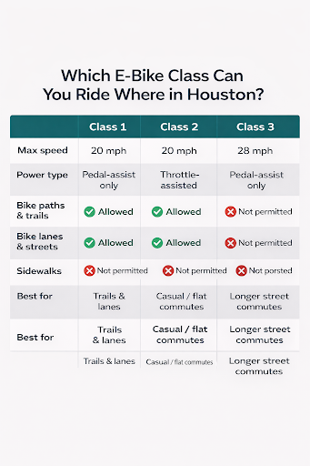
E-Bike Laws in Texas , What Houston Cyclists Need to Know
E-Bike Class | Description |
Class 1 | Pedal-assist only, max 20 mph. Allowed on all bike paths, multi-use trails, and bike lanes |
Class 2 | Throttle-assisted, max 20 mph. Also allowed on most bike paths and lanes |
Class 3 | Pedal-assist, max 28 mph. Generally not permitted on multi-use trails; street and bike lane use only |
Helmet rule | Texas law requires helmets for riders under 18. Adult riders are not required by state law but helmets are strongly recommended |
Traffic laws | E-bikes follow the same traffic laws as conventional bicycles , stop at all signals, ride with traffic, yield at crosswalks |
Sidewalks | Riding e-scooters and e-bikes on sidewalks is not permitted in Houston , use bike lanes and roadways |
Best Cycling Routes and Trails in Houston
- Buffalo Bayou Park Trail: A 10-mile paved trail winding through the heart of the city from downtown to Memorial Park. Flat, scenic, car-free , the gold standard for urban cycling in Houston
- Main Street / METRORail corridor: Protected bike infrastructure parallels the Red Line for much of its downtown–Museum District stretch
- Lawndale Street Bike Lane: Telephone Road to Forest Hill Boulevard in southeast Houston , one of the newer protected lanes built under the Houston Bike Plan
- Telephone Road corridor: A $25 million transformation of Telephone Road between Lawndale and South Loop 610, adding protected bike lanes, improved sidewalks, and safer crosswalks
- North Main Street: Redesigned corridor with high-comfort bike lanes between Airline Drive and Boundary Street, connecting to METRO improvements on Airline Drive
🌡️ Cycling in Houston’s Heat , Practical Tips Start earlier: Houston’s summer heat peaks mid-afternoon. A 6:30–7:00 AM departure is dramatically more comfortable than 8:30 AM. Shower access: Many Houston employers in the Medical Center, Energy Corridor, and downtown now offer commuter shower facilities , ask HR before you assume yours doesn’t. Winter is ideal: Houston’s mild winters (average January high: 63°F) make October–March the easiest cycling months with little weather interference. Hydration: Carry at least 24 oz of water for any ride over 3 miles in summer months. BCycle + Rail: Ride BCycle to the nearest METRORail station, take the train, and pick up another BCycle at the destination. The hybrid approach works well across a 5–10 mile commute. |
Option 4: Electric Scooters for First- and Last-Mile Trips
Electric scooters fill a critical gap in Houston’s green commute ecosystem: the first- and last-mile problem. METRO’s Park & Ride drops you at a transit center, but your office might still be half a mile away. That’s where e-scooters shine. Houston’s extensive network of bike lanes and trails makes it particularly well-suited for scooter travel, especially in the Inner Loop.
- Buffalo Bayou Park: One of the most popular e-scooter routes in the city , flat, scenic, car-free path between downtown and Memorial Park
- Downtown Houston: Dedicated bike lanes along multiple major streets give scooter riders safe access to Discovery Green, Market Square Park, and the Theater District
- Museum District: Connecting institutions along Main Street makes e-scooters a natural fit for short hops between destinations
⚠️ Houston E-Scooter Rules to Know No sidewalk riding: Houston regulations prohibit e-scooters on sidewalks. Use bike lanes and roadways only. Traffic law compliance: Obey all traffic signals, signs, and lane markings , you share the road with larger vehicles. Parking: Scooters must be parked in designated areas or spots that do not obstruct pedestrian traffic, doorways, or driveways. App-based rentals: Most dockless scooter services operate through smartphone apps , ensure your phone is charged before setting out. Helmet: Not legally required for adults in Texas, but strongly recommended for all riders. |
Option 5: Carpooling and Vanpooling Programs
Carpooling and vanpooling are among the most impactful and underused green commuting options in Houston. Each car removed from the daily commute eliminates up to 10,000 pounds of carbon tailpipe emissions annually (EPA Greenhouse Equivalencies Calculator). Houston’s extensive HOV lane network , operating on I-10, I-45, US-290, US-59/I-69, and other major corridors , means carpool and vanpool riders consistently reach downtown faster than solo drivers, even during peak rush hour.
The Houston-Galveston Area Council (H-GAC) runs Commute Solutions, a free regional program that has helped over one million Greater Houston commuters find alternatives to driving alone. H-GAC reports that employees who use commuter benefits save an average of $790 per year, while employers save about $40 per month per employee in payroll taxes through pre-tax commuter benefit programs. Learn more at YourCommuteSolution.org.
Carpool Apps and Matching Tools
- Carma app (free): GPS-enabled real-time ridematching. Drivers are reimbursed for costs when they carry riders. Best for Inner Loop and close-in suburban commuters. Free to join
- Waze Carpool: Integrated into the Waze navigation app , drivers set up a carpool account and are matched with nearby riders heading the same direction. Free for riders; drivers receive per-mile reimbursement at IRS rates
- METRO STAR Ridematching: METRO’s free ridematching service connects people with similar commutes for both carpools (2–5 people) and vanpools (5–15 people)
Vanpooling: METRO STAR and MetroVan
H-GAC’s MetroVan program covers the entire Houston-Galveston region, offering 9–15 passenger full-sized vans for groups commuting 10+ miles. The miniPOOL program offers 5–8 passenger minivans for commuters traveling through the Katy Freeway (I-10 west of Loop 610), West Loop 610, and US-59 south corridors , three of Houston’s most congested commute routes.
- First month free: All new vanpool participants ride free for their first month
- $35/month subsidy: Monthly fare subsidy available to all MetroVan participants throughout the region
- $50/month subsidy: Higher subsidy available to miniPOOL participants in the three designated congested corridors
- Guaranteed Ride Home: Vanpool participants get free emergency rides home , 3 per year for MetroVan, 5 per year for miniPOOL
- Contact: Commute Solutions at 713-627-3200 or vanpool.org for matching assistance
Program | Best For / Details |
Carpool (2–5 people) | Inner Loop / close-in suburbs; apps: Carma, Waze Carpool, METRO STAR ridematching |
MetroVan (9–15 people) | Long-distance suburban commuters; $35/month subsidy; 3 free emergency rides/year |
miniPOOL (5–8 people) | Katy Freeway, West Loop, US-59 south corridors; $50/month subsidy; 5 free emergency rides/year |
Commute with Enterprise | Company-sponsored vanpools; Enterprise provides and maintains the van |
HOV lane access | All carpools and vanpools of 2+ people get free use of HOV lanes on I-10, I-45, US-290, and US-59 |
Option 6: Electric Vehicles , Houston’s Growing EV Ecosystem
If you drive and want to green your commute without giving up your car, Houston’s EV charging infrastructure has expanded dramatically. The Greater Houston region now has 692 public Level 2 charging stations and 156 DC Fast Chargers, totaling approximately 10,960 charging ports across Harris, Fort Bend, Galveston, Waller, and Chambers Counties. Public charging station availability has grown more than 30% since April 2024.
Between July 2022 and the end of 2025, the number of electric vehicles registered in Texas more than tripled to 456,667 statewide, with 39,831 registered in Harris County alone , according to TxDOT’s Electric Vehicle Infrastructure Plan. The Houston Climate Action Plan includes a goal to increase EVs to 30% of new car sales by 2030.
Houston’s Major EV Charging Networks
- Tesla Supercharger: Multiple locations across Greater Houston, concentrated along I-10, US-59, and the Inner Loop. The most extensive fast-charging network for Tesla owners
- Ionna Rechargery (Washington Avenue): A new automaker-backed charging hub (BMW, GM, Honda, Hyundai, Kia, Mercedes-Benz, Stellantis, Toyota) that opened in 2025 on Washington Avenue , offering DC fast chargers with amenities including covered canopies, WiFi, and restrooms
- EVgo: DC fast charging stations throughout Harris County, Waller County, Fort Bend County, and Galveston County , supports CCS and CHAdeMO standards
- bp pulse Gigahub (Westchase): The first bp pulse Gigahub in the United States, at bp’s Houston headquarters , 24 high-speed DC fast chargers using Tritium 150kW chargers, open to the public
- ChargePoint and Blink: Level 2 charging networks with stations at office parks, shopping centers, and hotels throughout the metro area
Where EV Charging Is Most Concentrated in Houston
- Inner Loop neighborhoods: Downtown, Montrose, Midtown, River Oaks , highest density of Level 2 and DC fast charging
- I-10 corridor: Dense charging corridor from Loop 610 west through Katy and beyond
- US-59/I-69 corridor: Stations through Greenway Plaza, Sugar Land, and Missouri City
- George Bush Intercontinental Airport (IAH): EV charging in the Ecopark and terminal garages
- Suburban retail hubs: Memorial City Mall, Willowbrook Mall, Pearland Town Center, First Colony Mall
🔌 Finding EV Chargers in Houston PlugShare app: Best community-verified map of all public chargers in Houston; shows real-time availability and recent check-ins. plugshare.com Evolve Houston: Local non-profit tracking Houston EV infrastructure gaps; their RISE (Regional Infrastructure Study for Electrification) report identifies underserved areas. evolvehouston.org TxDOT EV Planning Map: Statewide map of all funded and planned charging corridors. txdot.gov DOE Alternative Fuels Data Center: Official federal database of all public charging stations. afdc.energy.gov Home charging tip: Over 95% of EV charging happens at home. A Level 2 home charger (240V) typically charges an EV to full overnight. Federal tax credits and Texas utility incentives may offset installation costs. |
Option 7: HOV and HOT Lanes , Rewarding Green Choices
Houston’s High Occupancy Vehicle (HOV) lane network is one of the most extensive in the country, running on I-10, I-45 North and South, US-290, US-59/I-69, and other major corridors. Carpools and vanpools with 2 or more occupants use HOV lanes for free, consistently saving 15–40 minutes each way on congested corridors during peak hours.
METRO has also converted many HOV lanes to High Occupancy Toll (HOT) lanes , allowing single-occupancy vehicles to pay a variable toll to access the lanes when they have available capacity. For green commuters, this is relevant in two ways: it funds HOV lane expansion, and it means your carpool remains free even on converted HOT lane corridors.
- I-10 Katy Managed Lanes: The most prominent example , the widened and managed lanes west of Loop 610 offer reliable travel times for carpools and toll-paying solo drivers alike
- HOV qualification: In Texas, 2 or more occupants (including the driver) qualifies a vehicle for HOV lane use statewide
- Park & Ride + HOV: METRO express buses use HOV lanes by definition , one of the strongest arguments for the Park & Ride system over solo driving
Option 8: Walking , The Zero-Emissions Commute
Walking to work or to a transit stop is the greenest commute option that exists. H-GAC’s Commute Solutions program recommends walking as viable for commuters who live within 1 mile of their workplace. For transit commuters, walking to a bus stop or METRORail station is part of every trip. Houston’s average commute time is approximately 34 minutes , two minutes above the national average , and reducing driving time, even partially, makes a meaningful impact.
Houston’s walkability varies dramatically by neighborhood. The most walkable areas for commuters are: downtown and Midtown (direct METRORail and BCycle access); Montrose and the Museum District (dense transit and bike infrastructure); EaDo and the East End (Green Line rail access and growing bike lanes); and the Heights (bus network and Trail connectivity). Suburban areas generally require transit or vehicle to reach work destinations.
🚶 Improving Houston’s Pedestrian Infrastructure
|
Option 9: Telework and Compressed Work Weeks
The greenest commute is no commute at all. Telework , working from home one or more days per week , eliminates vehicle miles traveled entirely for those days. H-GAC’s Commute Solutions identifies telework as an “excellent, convenient zero-commute solution” and notes that car insurance premiums can actually decrease with reduced vehicle mileage, adding an unexpected financial benefit.
A compressed work week (4×10, 9/80, or 3×36 schedule) removes four to sixteen commute trips per month, saving an estimated $300 to $1,300 annually in commuting costs. For Houston commuters, combining two work-from-home days with a compressed schedule can reduce annual commute trips by more than 100 , a significant carbon and cost reduction without changing where you live or what you drive.
- 4×10 schedule: Four 10-hour days, one day off per week , removes 52 round-trip commutes annually
- 9/80 schedule: Nine 9-hour days over two weeks with one Friday off every two weeks , removes 26 round-trip commutes annually
- Hybrid model: 2 WFH days per week combined with 3 commute days reduces annual commute trips by over 100 compared to 5-day in-office schedule
Choosing the Right Green Commute Option for Houston
No single green commute option works for everyone in a city as large and decentralized as Houston. Here’s a quick-match guide based on your home location, distance, and priorities:
Your Situation | Best Green Option | Key Resource |
Live near Red/Green/Purple Line corridor | METRORail , fastest, lowest-emissions, easiest | ridemetro.org , trip planner and GoMETRO app |
Suburban commuter, 15–40 miles from downtown | Park & Ride bus via HOV lanes | ridemetro.org/pages/parkride.aspx |
Inner Loop resident, commute under 5 miles | BCycle or e-bike, walk, or e-scooter | houston.bcycle.com |
Must drive but want to cut costs and emissions | Carpooling via Carma or Waze Carpool + HOV lanes | yourcommutesolution.org |
Group of 5–15 on same suburban corridor | MetroVan or miniPOOL vanpool + HOV lanes | vanpool.org or 713-627-3200 |
Drive solo but want zero-emission miles | Electric vehicle + home and public charging | evolvehouston.org/local-charger |
Can work remotely at least part-time | Telework / compressed work week , zero commute days | H-GAC Commute Solutions: yourcommutesolution.org |
Houston’s Green Commute Future , and What You Can Do Today
Houston is no longer just a car city. The combination of a 22.7-mile light rail network carrying 35,000+ daily riders, 29 Park & Ride lots with 33,000 spaces, 400+ miles of bike lanes, nearly 11,000 public EV charging ports, and a robust network of carpool and vanpool programs gives Houstonians more genuine green commute choices than ever before.
The city’s Climate Action Plan sets a clear direction: 40% emissions reduction by 2030, carbon neutral by 2050. Transportation , at 47% of the city’s total GHG output , is where individual choices matter most. Switching from solo driving to any of the options in this guide is one of the highest-impact sustainability decisions you can make as a Houstonian.
Start with the option that removes the most friction for your specific commute. If you’re in the Inner Loop, that might be Houston BCycle and METRORail. If you’re a suburban commuter on I-45, it’s the Park & Ride. If you drive an older gas vehicle, it might be joining a vanpool and using HOV lanes. And if your employer is flexible, two work-from-home days per week may be the single most effective change you can make. For more ways to reduce your commuting costs, see our detailed guide on ridesharing vs. car ownership in Houston.
🚗 Ready to Make Your Houston Commute Greener? Whether you’re a daily driver looking to cut costs, a rideshare driver building a sustainable routine, or a commuter exploring Houston’s transit options for the first time , SafeTrip can help you navigate the choices that work for your life and your route. We help Houstonians commute smarter , with practical, up-to-date guidance on transit, rideshare, EVs, and everything in between. 👉 Contact SafeTrip today for a free consultation , and start commuting with confidence. |
Sources & Official Resources
- City of Houston Climate Action Plan: greenhoustontx.gov/climateactionplan
- METRO Houston , Official Transit Information: ridemetro.org
- METRO Park & Ride Routes and Locations: ridemetro.org/pages/parkride.aspx
- METRORail Wikipedia (ridership data, Q4 2025): en.wikipedia.org/wiki/METRORail
- H-GAC Commute Solutions: yourcommutesolution.org
- Houston BCycle , Bike Share: houston.bcycle.com
- Evolve Houston EV Charging Data: evolvehouston.org/local-charger
- TxDOT Electric Vehicle Infrastructure Plan: txdot.gov/about/newsroom/stories/meeting-demand-for-electric-vehicle-infrastructure.html
- Houston Bike Plan , City Planning Dept.: houstontx.gov/planning (Houston Bike Plan)
- METRONow Plan (February 2025): Houston Public Media coverage